What Are Plate Tectonics?
Seismic Zones
Recycling of Crustal Material
What is an earthquake?
What are Seismic Waves?
Magnitude and Intensity of an Earthquake
Richter Scale for Earthquakes
What Are Plate Tectonics?
To experience the plate tectonics--the jostling of giant plates that carry continents and oceans--try this experiment: Hold your hand in front of you and watch you finger nails grow. That is roughly the average speed of a tectonic plate. Even at this slow rate, over time movement can produce dramatic and deadly consequences.
Plate tectonics tells us that the Earth's rigid outer shell, or lithosphere, is broken into a mosaic of oceanic and continental plates which can slide over the plastic aesthenosphere, which is the uppermost layer of the mantle. The plates are in constant motion. Where they interact, along their margins, important geological processes take place, such as the formation of mountain belts, earthquakes, and volcanoes.
The lithosphere covers the whole Earth. Therefore, ocean plates are also involved, more particularly in the process of sea-floor spreading. This involves the midocean ridges which are a system of narrow submarine cracks that can be traced down the center of the major oceans. The ocean floor is being continuously pulled apart along these midocean ridges. Hot volcanic material rises from the Earth's mantle to fill the gap and continuously forms new oceanic crust. The midocean ridges themselves are broken by offsets know as transform faults.
Map of the Earth's Plate Boundaries
Seismic ZonesPlate tectonics revealed that there are four types of seismic zones. The first follows the line of midocean ridges. Activity is low, and it occurs at very shallow depths. The lithosphere is very thin and weak at these boundaries, so the strain cannot build up enough to cause large earthquakes. Associated with this type of seismicity is the volcanic activity along the axis of the ridges (for example, Iceland, Azores, Tristan da Cunha).
The second type of earthquake associated with plate tectonics is the shallow-focus event unaccompanied by volcanic activity. The San Andreas fault is a good example of this. In faults like this, two mature plates are scraping by one another. The friction between the plates can be so great that very large strains can build up before they are periodically relieved by large earthquakes. Although, activity does not always occur along the entire length of the fault during any one earthquake. For instance, the 1906 San Francisco event was caused by breakage only along the northern end of the San Andreas fault.
The third type of earthquake is related to the collision of oceanic and continental plates. One plate is thrust or subducted under the other plate so that a deep ocean trench is produced. This type of earthquake can be shallow, intermediate, or deep, according to its location on the downgoing lithospheric slab. Such inclined planes of earthquakes are know as Benioff zones.
The fourth type of seismic zone occurs along the boundaries of continental plates. Typical of this is the broad swath of seismicity from Burma to the Mediterranean, crossing the Himalayas, Iran, Turkey, to Gilbraltar. Within this zone, shallow earthquakes are associated with high mountain ranges where intense compression is taking place. Intermediate-and deep-focus earthquakes also occur and are known in the Himalayas and in the Caucasus. The interiors of continental plates are very complex, much more so than island arcs. For instance, we do not yet know the full relationship of the Alps or the East African rift system to the broad picture of plate tectonics.
Recycling of Crustal Material
If the Earth was not to be blown up like a balloon by the continual influx of new volcanic material at the ocean ridges, then old crust must be destroyed at the same rate where plates collide. The required balanced occurs when plates collide, and one plate is forced under the other to be consumed deep in the mantle, a process kown as plate subduction.
It is now known that there are seven major crustal plates, subdivided into a number of smaller plates. They are about 80 kilometers thick, all in constant motion relative to one another, at rates varying from 10 to130 millimeters per year. Their pattern is neither symmetrical nor simple. As more and more are learned about the major plates; many complicated and intricate maneuvers are taking place. We know that most large-scale geological action--such as the formation of mountains, rift valleys, volcanoes, earthquakes, faulting--is due to different types of interaction at plate boundaries.

Plate Tectonic Interactions
The Relationship between Plate Tectonics and Earthquakes
The Earth is formed of several layers that have very different physical and chemical properties. The outer layer, which averages about 70 kilometers in thickness, consists of about a dozen large, irregularly shaped plates that slide over, under and past each other on top of the partly molten inner layer. Most earthquakes occur at the boundaries where the plates meet. In fact, the locations of earthquakes and the kinds of ruptures they produce help scientists define the plate boundaries.
There are three types of plate boundaries: spreading zones, transform faults, and subduction zones

Cross section of the Earth's Plate Tectonic Structure
At spreading zones, molten rock rises, pushing two plates apart and adding new material at their edges. Most spreading zones are found in oceans; for example, the North American and Eurasian plates are spreading apart along the mid-Atlantic ridge. Spreading zones usually have earthquakes at shallow depths (within 30 kilometers of the surface).
Transform faults are found where plates slide past one another. An example of a transform-fault plate boundary is the San Andreas fault, along the coast of California and northwestern Mexico. Earthquakes at transform faults tend to occur at shallow depths and form fairly straight linear patterns.
Subduction zones are found where one plate overrides, or subducts another, pushing it downward into the mantle where it melts. An example of a subduction-zone plate boundary is found along the northwest coast of the United States, western Canada, and southern Alaska and the Aleutian Islands. Subduction zones are characterized by deep-ocean trenches, shallow to deep earthquakes, and mountain ranges containing active volcanoes. Earthquakes can also occur within plates, although plate-boundary earthquakes are much more common. Less than 10 percent of all earthquakes occur within plate interiors.
As plates continue to move and plate boundaries change over geologic time, weakened boundary regions become part of the interiors of the plates. These zones of weakness within the continents can cause earthquakes in response to stresses that originate at the edges of the plate or in the deeper crust.
What is an earthquake?

An earthquake is the vibration, sometimes violent, of the Earth's surface that follows a release of energy in the Earth's crust. This energy can be generated by a sudden dislocation of segments of the crust, by a volcanic eruption, or even by manmade explosions.
But the most common kind of quakes, the most destructive and the kind people generally have in mind when we think of earthquakes are the ones that are caused by the sudden dislocation of large rock masses along the faults within the earth's crust. These are known as tectonic earthquakes.
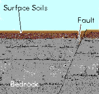
A fault is a fracture within some particular rocky mass within the earth's crust. Fault sizes can vary greatly, as some faults can be miles long. Earthquakes are caused by active faults, which are, faults along which the two sides of the fracture move with respect to each other.
In short, an earthquake is caused by the sudden movement of the two sides of a fault with respect to another.
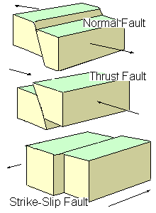
There are three different groups of faults, depending on the way they move (refer to
diagram): 
-
Normal faults
These occur in response to pulling or tension: the overlying block moves down the dip of the fault plane.
- Thrust (reverse) faults
These occur in response to squeezing or compression: the overlying block moves up the dip of the fault plane.
- Strike-slip (lateral) faults
These occur in response to either type of stress: the blocks move horizontally past one another.
The slow and continuous movement of two sides of an active fault relative to one another can noticed over time; this movement is called fault slip. The rate of this movement may be as little as a few inches or so per year. The movement of these two sides of the fault cannot be an entirely smooth, easy type of movement. We can infer the existence of conditions or forces deep with the fault which resist this relative motion of the two sides of the fault. This is because the motion along the fault is accompanied by the gradual buildup of elastic strain energy within the rock along the fault. The rock stores this strain like a giant spring being slowly tightened.
Eventually, the strain along the fault becomes too much for the rock to bear. The fault then ruptures, or suddenly moves a comparatively large distance in a short amount of time. The rocky masses which form the two sides of the fault then snaps into a new position. This snapping back into position, upon the release of strain, is the elastic rebound.
The rupture of the fault also results in the sudden release of the strain energy that had been built up over the years. The most important form that this suddenly released energy takes is that of seismic waves.
What are Seismic Waves?
Seismic energy travels through the crust in the form of waves. There are two basic kinds of seismic waves: body waves and surface waves. Body waves travel outward in all directions, including downward, from the quake's focus -- that is, the particular spot where the fault first began to rupture. Surface waves, by contrast, are confined to the upper few hundred miles of the crust. They travel parallel to the surface, like ripples on the surface of a pond. They are also slower than body waves.
P-waves
Following an earthquake, the body waves strike first. The fastest kind are the primary waves, or P-waves. People often report a sound like a train just before they feel a quake, which is the P-wave moving as an acoustic wave in the air. P-waves can travel through solids, liquids and gases. When these waves travel throught the air, it is called sound waves. In most rocks, p-waves will travel about 1.7 and 1.8 times faster than the secondary, or S-waves.
S-waves
A person in a building perceives the arrival of S-waves as a sudden powerful jolt, as if a giant has pounded his fist down on the roof. Finally, the surface waves strike. In very strong earthquakes, the up-and-down and back-and-forth motions caused by surface waves can make the ground appear to roll like the surface of the ocean, and can literally topple buildings over. This wave can only travel through solids, and do no travel through the earth's core.
The picture below shows how an S wave travels by vibrating up and down. The black box shows how an area of rock deforms as the wave passes. The hammer represents the initial release of energy at fault rupture
Magnitude and Intensity of an Earthquake
The Richter Magnitude Scale
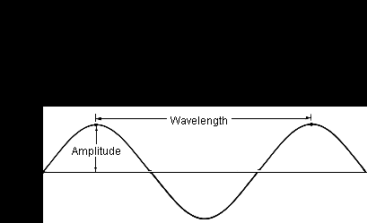
eismic waves are the vibrations from earthquakes that travel through the Earth; they are recorded on instruments called seismographs. Seismographs record a zig-zag trace that shows the changing amplitude of ground oscillations beneath the instrument. Sensitive seismographs, which greatly magnify these ground motions, can detect strong earthquakes from sources anywhere in the world. The time, location, and magnitude of an earthquake can be determined from the data recorded by seismograph stations. The richter scale was developed as a mathematical device to compare the size of eathquakes.
The magnitude of an earthquake is determined from the logarithm of the amplitude of waves recorded by seismographs. On the Richter Scale, magnitude is expressed in whole numbers and decimal fractions. For example, a magnitude of 5.0 might be computed for a moderate earthquake, and a strong earthquake might be rated as magnitude 6.0. Each whole number increase in magnitude represents a tenfold increase in measured amplitude; as an estimate of energy, each whole number step in the magnitude scale corresponds to the release of about 31 times more energy than the amount associated with the preceding whole number value.
The Richter Scale is not used to express damage. An earthquake in a densely populated area which results in many deaths and considerable damage may have the same magnitude as a shock in a remote area that does nothing more than frighten the wildlife. Large-magnitude earthquakes that occur beneath the oceans may not even be felt by humans. Earthquakes with magnitude of about 2.0 or less are usually called microearthquakes; they are not commonly felt by people and are generally recorded only on local seismographs. Events with magnitudes of about 4.5 or greater--there are several thousand such shocks annually--are strong enough to be recorded by sensitive seismographs all over the world. Great earthquakes, such as the 1964 Good Friday earthquake in Alaska, have magnitudes of 8.0 or higher. On the average, one earthquake of such size occurs somewhere in the world each year.
The Modified Mercalli Intesity Scale
The effect of an earthquake on the Earth's surface is called the intensity. The intensity scale consists of a series of certain key responses such as people awakening, movement of furniture, damage to chimneys, and finally--total destruction. The current intensity scale being used in the U.S. is the Modified Mercalli (MM) Intensity Scale. The scale is composed of 12 increasing levels of intensity that range from imperceptible shaking to catastrpic destruction. This scale does not have a mathmatical basis, instread it is an arbitrary ranking system based on observed effects.

